5 Things To Know About Missouri’s Next Winter Storm
This story was updated to reflect the latest graphics published by the National Weather Service in Kansas City on the afternoon of 2/11/2025. Information now includes more of a timeline for when snow/ice will move across West Central Missouri and more details on the impacts it will have in various parts of the state.
As we prepare for our second winter storm of the season, here are five things you need to know about the winter storm heading our way.
The Quiet Before The Storm
When this winter storm was predicted, three separate snow events were expected: one last night and today, followed by rounds two tonight and tomorrow, and one as we head into the weekend.
If there's anything good about all this, the snow event that should be happening now doesn't seem to be much of an event. Our forecast from Weatherology calls for a dusting of snow today and overnight, which is undoubtedly better than the inch or two of snow originally predicted. The National Weather Service's forecast for Sedalia calls for a slight chance of snow through 5:00 AM CDT on Wednesday, February 12, 2025.

Storm Wave Timing
So what's the current thinking on the storm's timing, and how much snow will we get?
The National Weather Service predicts a strong winter storm capable of producing significant snowfall and a light glaze of ice will impact the region tonight, Tuesday, February 11, 2025, through tomorrow night. Snow accumulations between 4 and 8 inches are expected for the area.
From Wednesday night, February 12, 2025, through Friday morning, February 14, 2025, expect bitterly cold wind chills ranging from zero to ten below.
Another storm capable of minor snow accumulations is possible Friday night, February 14, 2025, through Saturday night, February 15, 2025.
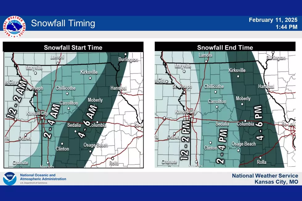
You can look at this map from the National Weather Service to see what time the snow will be hitting your area overnight and what time it will be moving out Wednesday afternoon.
What To Expect With This Storm.

A Winter Storm Warning is in effect from midnight Wednesday, February 12, 2025, through 9:00 PM CST.
Heavy mixed precipitation is expected. Snow accumulations between four and eight inches and a light glaze of ice are expected through 9:00 PM CST on Wednesday, February 12, 2025. These conditions can make travel difficult, and hazardous conditions can impact your Wednesday commute.
While Kansas City and areas north of Highway 50 don't seem like they will be impacted by ice, areas south of Highway 50, like Sedalia, Warrensburg, and Knob Noster, could very well find themselves dealing with ice anywhere from a light glaze to a few hundredths of an inch, which may limit snow totals. For Wednesday, the National Weather Service expects moderate impacts from the snow, including hazardous driving conditions, closures, and disruption. They recommend delaying or postponing travel if possible.

After The Snow, Expect A Plunge Into The Cold
The area will experience much colder weather after the snowfall ends on Wednesday evening. Weatherology predicts a high of 29 on Wednesday, February 12, 2025; expect a low of 7 on Wednesday night, a high of 22 on Thursday, and a low of 6 on Thursday night before we rebound with a high of 39 on Friday.
The National Weather Service warns of single-digit to below-zero wind chills mid- to late week. I would not be surprised to see a warning issued about the cold.


The Final Wave and Expected Longer Range Outlook
Friday's warm-up to 39 will precede the final wave of this storm system. Weatherology predicts scattered rain showers on Friday night, February 14, 2025. That's followed by rain becoming mixed precipitation with a high of 42 on Saturday, February 15. The National Weather Service indicates we might see some additional minor snow accumulations Friday night through Saturday night.
The extended outlook for Missouri from Tuesday, February 18, 2025, through Monday, February 24, calls for temperatures that will likely be below normal, with above-normal precipitation
LOOK: 20 American foods that raise eyebrows outside of the US
Gallery Credit: Charlotte Barnett
More From Mix 92.3